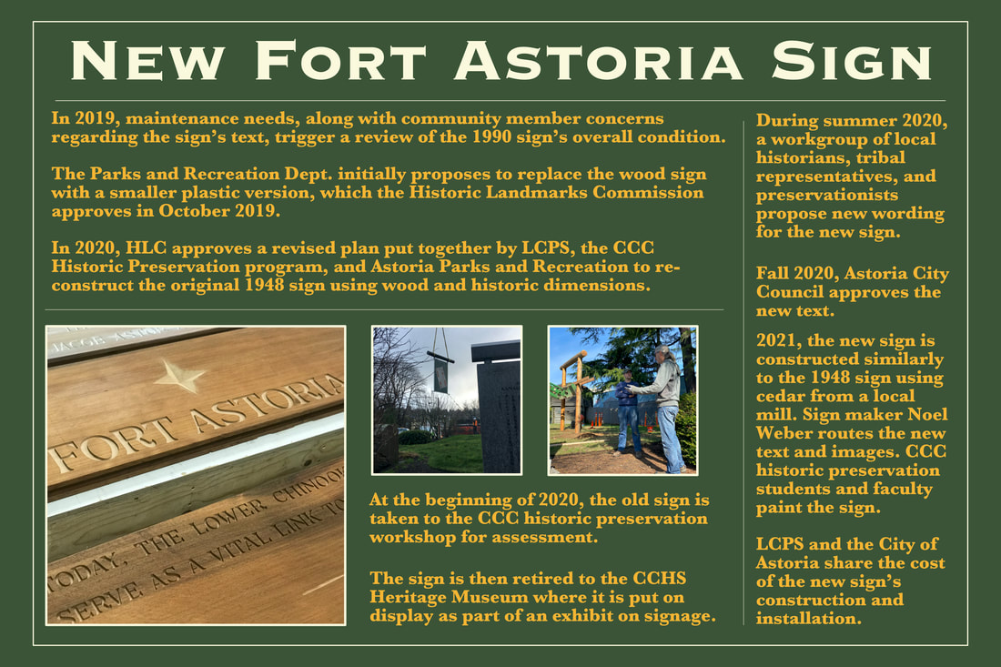
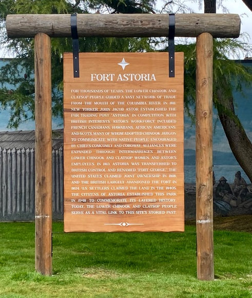
About the 2022 Fort Astoria sign:
“Historic signs give continuity to public spaces, becoming part of the community memory. They sometimes become landmarks in themselves, almost without regard for the building to which they are attached, or the property on which they stand.” –Michael Auer, NPS
Historical Background & Context
In 1935, the Astoria Chamber of Commerce announced that the restoration and proper marking of prominent historical sites around Astoria had become a priority for the chamber. The location and history of Fort Astoria were of much public interest in the 1930s. Remnants of fort pickets had been uncovered in 1931, and in 1936 workmen painted white lines in the streets to indicate the location of the original fort site. Explanatory signs were also hung at least one street corner that provided a map and key of the old fort site.
In 1940, Clatsop County, who owned the corner lot at 15th and Exchange, decided to turn the property over to the city, hoping that the community would memorialize the site but with the understanding that the city itself was not in the position to financially aid the development of the site. Although several groups showed an interest in creating a permanent marker there, the site remained undeveloped.
In 1948, the city received an offer to purchase the lot to be used for parking. An editorial from the Astoria Budget, in the Spring of 1948, titled “To Save Historic Site?” made a pointed argument for preservation:
“Astorians interested in the preservation of historical sites would do well to start some planning for use of the corner lot at 15th and Exchange streets, only remaining publicly-owned portion of the site of the John Jacob Astor party’s Fort Astoria, before the city sells it for a parking lot. This lot was set aside at the request of the Kiwanis club some years ago, but no marker has been set up there to show the old fort’s location. We have been taken to task before this for our neglect of historical sites, and with some reason. Visitors will certainly take us to task if we abandon our last possible location for a Fort Astoria marker in favor of a parking lot. If funds could be raised, the lot in question might well be converted into a small park area, containing a suitably marked stone, a small replica of the fort, or some other marker which tourists could see. We all well know that visitors here like to see some evidence of our historic past. When they find historic sites abandoned or turned into parking lots, they are not pleased, and their respect for the people of our community and for the community itself falls sharply.”
Due to the site’s historical importance, Astoria City Council postponed the sale for 60 days to give those groups interested in preserving the site time to develop a community plan.
In April of 1948, Walter Johnson, president of the Clatsop County Historical Society, initiated a program to mark and permanently maintain the site. A group of fifteen civic and patriotic organizations, referred to as the “Fort Astoria Defenders,” met at the Chamber of Commerce “to raise the memory of Fort Astoria from a patch of brambles at Fifteenth and Exchange.” This group included: Astoria Garden Club, Seaside Garden Club, Women’s Club of Seaside, American Association of University Women, Daughters of the American Revolution, American Legion, Astoria Chamber of Commerce, Pacific Grange, Pomona Grange, Astoria Gyro Club, Astoria and Warrenton Lions Clubs, Astoria Kiwanis Club, Seaside and Astoria Elks, and Angora Hiking Club.
In May of 1948, Astoria City Council formally turned over the city-owned lot to the Clatsop County Historical Society for preservation as a Fort Astoria marker. Project manager Dr. Walter Hay coordinated several community work parties over the summer. Walter Johnson, president of Clatsop County Historical Society and Ebba Wicks, project architect, developed formal plans for the site. Byers Brothers Construction, City Lumber, Astoria Granite Works and Pacific Power & Light donated substantial site work along with many other groups and members of the community.
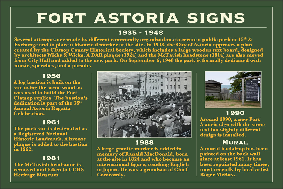
The focal point of the completed, landscaped site was a large text-board, with a fort map carved on the reverse, supported by a log frame. Wicks & Wicks Architects designed the large rustic marker. Phil Parrish, chairman of the memorial committee of the Oregon Historical Society, wrote the text for the sign. The Oregon Highway Commission constructed the text board and Pacific Power & Light installed the log frame.
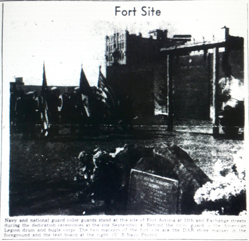
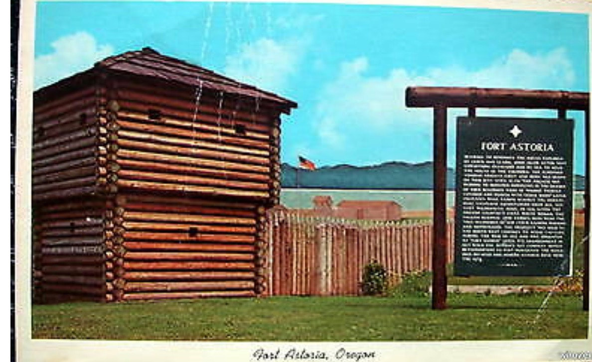
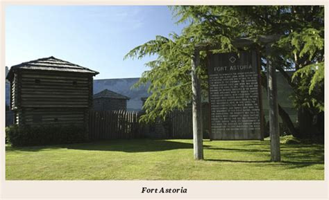
The dedication of the marker was held on September 4, 1948, with a parade through town culminating with several speeches and the raising of the American Flag at the site. In 1956, the park was further developed to include a replica of the blockhouse constructed of Wolmanized fir. The site was dedicated as a National Historic Landmark in 1962 and was hence included in the National Register of Historic Places when the register was established in 1966. Some discussion occurred in 1972 regarding an effort to reconstruct Astor’s fur-trading fort, led by Deskin Bergey, Rolf Klep and Ebba Wicks Brown but that expansion project never materialized.
In 1940, Clatsop County, who owned the corner lot at 15th and Exchange, decided to turn the property over to the city, hoping that the community would memorialize the site but with the understanding that the city itself was not in the position to financially aid the development of the site. Although several groups showed an interest in creating a permanent marker there, the site remained undeveloped.
In 1948, the city received an offer to purchase the lot to be used for parking. An editorial from the Astoria Budget, in the Spring of 1948, titled “To Save Historic Site?” made a pointed argument for preservation:
“Astorians interested in the preservation of historical sites would do well to start some planning for use of the corner lot at 15th and Exchange streets, only remaining publicly-owned portion of the site of the John Jacob Astor party’s Fort Astoria, before the city sells it for a parking lot. This lot was set aside at the request of the Kiwanis club some years ago, but no marker has been set up there to show the old fort’s location. We have been taken to task before this for our neglect of historical sites, and with some reason. Visitors will certainly take us to task if we abandon our last possible location for a Fort Astoria marker in favor of a parking lot. If funds could be raised, the lot in question might well be converted into a small park area, containing a suitably marked stone, a small replica of the fort, or some other marker which tourists could see. We all well know that visitors here like to see some evidence of our historic past. When they find historic sites abandoned or turned into parking lots, they are not pleased, and their respect for the people of our community and for the community itself falls sharply.”
Due to the site’s historical importance, Astoria City Council postponed the sale for 60 days to give those groups interested in preserving the site time to develop a community plan.
In April of 1948, Walter Johnson, president of the Clatsop County Historical Society, initiated a program to mark and permanently maintain the site. A group of fifteen civic and patriotic organizations, referred to as the “Fort Astoria Defenders,” met at the Chamber of Commerce “to raise the memory of Fort Astoria from a patch of brambles at Fifteenth and Exchange.” This group included: Astoria Garden Club, Seaside Garden Club, Women’s Club of Seaside, American Association of University Women, Daughters of the American Revolution, American Legion, Astoria Chamber of Commerce, Pacific Grange, Pomona Grange, Astoria Gyro Club, Astoria and Warrenton Lions Clubs, Astoria Kiwanis Club, Seaside and Astoria Elks, and Angora Hiking Club.
In May of 1948, Astoria City Council formally turned over the city-owned lot to the Clatsop County Historical Society for preservation as a Fort Astoria marker. Project manager Dr. Walter Hay coordinated several community work parties over the summer. Walter Johnson, president of Clatsop County Historical Society and Ebba Wicks, project architect, developed formal plans for the site. Byers Brothers Construction, City Lumber, Astoria Granite Works and Pacific Power & Light donated substantial site work along with many other groups and members of the community.
The focal point of the completed, landscaped site was a large text-board, with a fort map carved on the reverse, supported by a log frame. Wicks & Wicks Architects designed the large rustic marker. Phil Parrish, chairman of the memorial committee of the Oregon Historical Society, wrote the text for the sign. The Oregon Highway Commission constructed the text board and Pacific Power & Light installed the log frame.
The dedication of the marker was held on September 4, 1948, with a parade through town culminating with several speeches and the raising of the American Flag at the site. In 1956, the park was further developed to include a replica of the blockhouse constructed of Wolmanized fir. The site was dedicated as a National Historic Landmark in 1962 and was hence included in the National Register of Historic Places when the register was established in 1966. Some discussion occurred in 1972 regarding an effort to reconstruct Astor’s fur-trading fort, led by Deskin Bergey, Rolf Klep and Ebba Wicks Brown but that expansion project never materialized.
HISTORY OF ROADSIDE HISTORICAL MARKERS IN OREGON
|
The Oregon State Highway Commission began a program to install historical markers around the state in 1937. According to R. H. Baldock, State Highway Engineer in a letter dated September 15, 1949, “We started a rather extensive program in 1940, but our activities were curtailed during the war years and we have but recently renewed this program.” By 1949, they had installed roughly 30 signs:
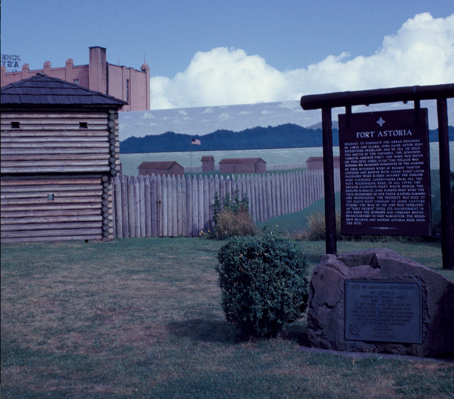
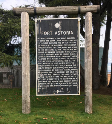
“While most of our signs are of the rustic type with log uprights, there are a number of locations where rubble masonry bases might be more appropriate. We have about 30 markers in at the present time and eventually, when sufficient signs have been installed to justify doing so, we contemplate issuing a brochure which will be distributed by our Travel Information Department for parties who might be interested in stopping to visit these historical points on their travels.” Brochures and travel guides were eventually produced. In 1966, the book Oregon’s Historical Markers by W. M. Scofield was published by Souvenir Publishing Co. of Pleasant Hill, Oregon.The Fort Astoria marker was included in this book of 76 historical markers, the only marker to require two pages, as it included an image of the back of the sign, the fort plan. “Hewn in wood these monuments have been erected in all parts of Oregon, recreating for all time these hallowed points which mark our most recent past.” At the time of its printing, there were eight markers located in Clatsop County: Fort Astoria, U.S. Custom House, Fort Clatsop, Fort Stevens State Park, Sunset Highway, The Tillamook Burn (Sunset Springs), Ecola, and Cannon Beach. The photo of the Fort Astoria marker included in Scofield’s book is the same photo that was provided by the Oregon Department of Transportation (ODOT) library. It is unclear what happened to the original marker but a replacement version was installed sometime around 1990. Photos from 2001 clearly show the newer sign as unpainted wood with a red metal frame. Later, the text board was painted black with white lettering and the metal frame was painted white. The map on the back was painted green, gray, and brown, with white lettering. |
|
|
|
|
ORIGINAL MARKER - DOCUMENTS & PHOTOGRAPHS
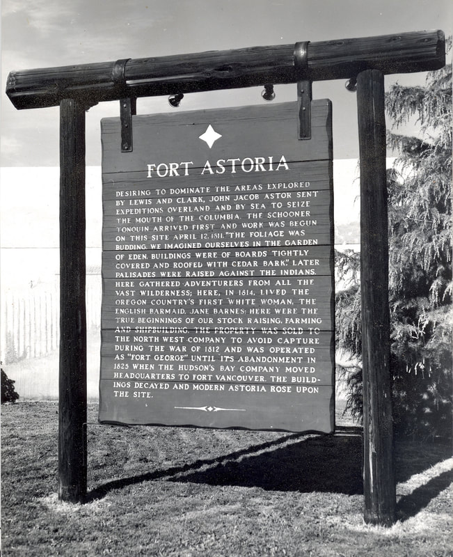
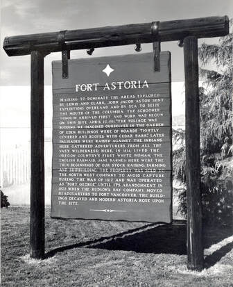
NPS photo, 1960s.
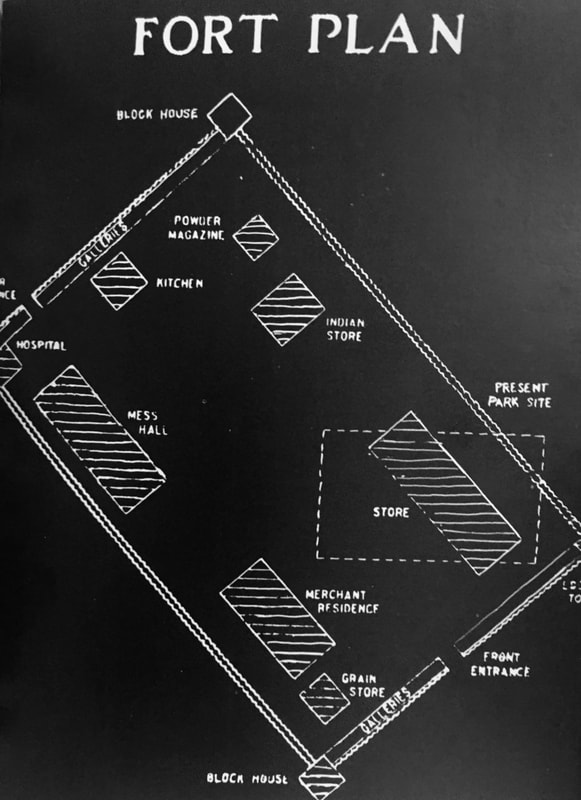
Image included in Scofied's book depicting the map on the back of the marker.
|
According to newspaper accounts, the original marker was constructed by the Oregon Highway Commission and was hung from a log frame installed by Pacific Power & Light. ODOT has provided us with a historic photograph of the original sign. Newspaper accounts state that the textboard was designed by Ebba Wicks, of Wicks and Wicks Architects. This is consistent with the construction of the sign being quite different than most of the Oregon’s historical markers made at that time. The Oregon Historical Society confirmed that they do not have these design plans in their Wicks archive.
The original marker was most likely constructed of cedar. It looks, from historical photos, to have been made of seven pieces of wood joined horizontally with a total size of 5’3”x 7’10”. The edges of the sign were constructed to have a rough-hewn, rustic appearance. The height of the horizontal boards, from top to bottom seem to be 16”, 8”, 16”, 8”, 16”, 16” and 14”. The vertical posts appear to be8” in diameter and approximately 10’ tall (above ground). The top log was 12” diameter with a length of roughly 10’. The edges of the top log were cut to have a rough appearance. The textboard was hung from the top log by two large metal brackets. Each bracket had three bolts, two of which went through the sign. Metal L-shaped brackets also held the bottom of the sign to the supporting vertical log posts on each side.In one historical photo, there are four spotlights attached to the top log, either illuminating the sign itself or the mural behind it. The top post and textboard were stained a very dark color, but the textboard itself appears to have also been painted at some early point, as there is photographic evidence of over-painting on the top metal brackets. The lettering, if standard to other historical markers routed by the highway commission, were at minimum 1 1/3” tall and 1/8” deep. Photographic evidence suggests that the letters in the main body of text were between 1.5” and 2” tall. Somewhat surprisingly, two lines on the original sign were routed over the horizontal joints, “FORT ASTORIA” and “AND SHIPBUILDING. THE PROPERTY WAS SOLD TO” although this was not unheard of, as signs for Umatilla County, Bannock War, and Joseph L. Meekall have similar split lines. The letters were likely painted and would have been white, or perhaps silver to increase visibility. Two decorative symbols were also included on the marker, a stylized star at the top of the sign,-approximately 7” or 8” tall, and a diamond-with-tails on each side at the bottom. Both symbols appear on other Oregon historical markers from the same period but usually in a slightly different combination. “Beaver Boards” generally had the image of a beaver carved on the top and the diamond-with-tails at the bottom, whereas most of the markers that had a star at the top similar to the Fort Astoria marker, also had a smaller star at the bottom. At least two other signs had the same symbol configuration as the Fort Astoria marker in 1966: Willamette Stone State Park and Beacon Rock. Although we have not located a clear photo of the back of the original Fort Astoria marker, we do have this newspaper account from 1948, “Plans and specifications for the textboard have been sent to the Oregon highway commission, which will construct the board. The board will bear the wording on one side and an outline map of the old fort on the other.” Also, an image described as from the back of the board is included in Scofield’s 1966 book, although it is hard to tell if it was carved, painted by hand, stenciled, or a combination of the above. It is not clear when the original 1948 marker was retired and if it was damaged, stolen, or lost. At some point between 1989 and 1997, the original sign was replaced. This replacement marker, constructed of vertically jointed fir framed in metal, is the marker that was removed from the site and transported to the Clatsop Community College historic preservation shop on January 24, 2020. |
Comparison of 1948 original, c. 1990 replacement, and 2022 reconstruction
|
|
|
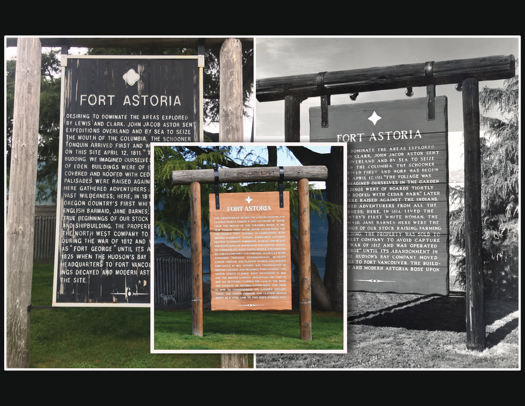
1948 and c. 1990 sign text:
Desiring to dominate the areas explored by Lewis and Clark, John Jacob Astor sent expeditions overland and by sea to seize the mouth of the Columbia. The schooner Tonquin arrived first and work was begun on this site April 12, 1811. "Foliage was budding. We imagined ourselves in the Garden of Eden. Buildings were of boards tightly covered and roofed with cedar bark." Later palisades were raised against the Indians. Here gathereed adventures from all the vast wilderness; here, in 1814, lived the Oregon Country's first white woman, the English barmaid, Jane Barnes; here were the true beginnings of our stock raising, farming and shipbuilding. The property was sold to the North West Company to avoid capture during the War of 1812 and was operated as "Fort George" until its abandonment in 1825 when the Hudson's Bay Company moved headquarters to Fort Vancouver. The buildings decayed and modern Astoria rose upon the site.
2022 sign text:
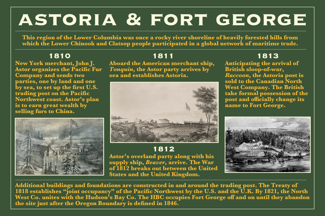
For thousands of years, the Lower Chinook and Clatsop people guided a vast network of trade from the mouth of the Columbia River. In 1811, New Yorker John Jacob Astor established the fur trading post “Astoria” in competition with British interests. Astor’s workforce included French Canadians, Hawaiians, African Americans, and Scots, many of whom adopted Chinook Jargon to communicate with Native people. Encouraged by Chiefs Comcomly and Coboway, alliances were expanded through intermarriages between Lower Chinook and Clatsop women, and Astor's employees. In 1813, Astoria was transferred to British control and renamed “Fort George.” The United States claimed joint ownership in 1818, and the British largely abandoned the fort in 1824. U.S. settlers claimed the land in the 1840s. The citizens of Astoria established this park in 1948 to commemorate its layered history. Today, the Lower Chinook and Clatsop people serve as a vital link to this site’s storied past.